by Gary Beers1
“A STORY OF THE WASHINGTON COUNTY UNORGANIZED TERRITORIES”
Prepared by John Dudley for Washington County (2017)
THE NATIVES AND THEIR LAND
Our limited knowledge of the past tells us that the Passamaquoddy or their forebears were the first to live in this place we call Washington County. Their knowledge and skills allowed them to live on the resources the land and waters provided. These nomadic people had no need for the concept of land ownership.
The Passamaquoddy (Passamaquoddy: Peskotomuhkati, Plural: Peskotomuhkatiyik) are a Native American/First Nations people who live in northeastern North America. Their traditional homeland, Peskotomuhkatikuk, straddles the Canadian province of New Brunswick and the U.S. state of Maine in a region called Dawnland. They are one of the constituent nations of the Wabanaki Confederacy.

EXPLORERS FROM EUROPE
The concept of land ownership came first with the Europeans who explored the Maine coast when they claimed the land for the king for whom they sailed. This concept was further solidified by the Europeans who attempted to settle here in 1604 and 1607. Successful settlement by Europeans and their descendants codified land ownership as given by Stanley Attwood in his Length and Breadth of Maine.
The Royal Charter issued by Charles I to the Colony of Massachusetts Bay March 4, 1628; through grants directly from the Colony after its assertion of a claim thereunder to Latitude 43 degrees, 43 minutes, 12 seconds and to 43 degrees, 49 minutes, 12 seconds in 1652 and 1673.
“The Province of Massachusetts Bay, which sent delegates to the Congress, was chartered by William and Mary on October 7, 1691. That charter is, strictly speaking, the basis of government of the States of Massachusetts and Maine.” We all know that the Passamaquoddy and other native peoples to this day challenge this concept we call land ownership.”
The political sovereignty and authority of the government of Maine is derived directly from the Act of Congress admitting Maine into the Union, passed March 3, 1820, and in consent of Massachusetts expressed in an act of its General Court passed on June 19, 1819.
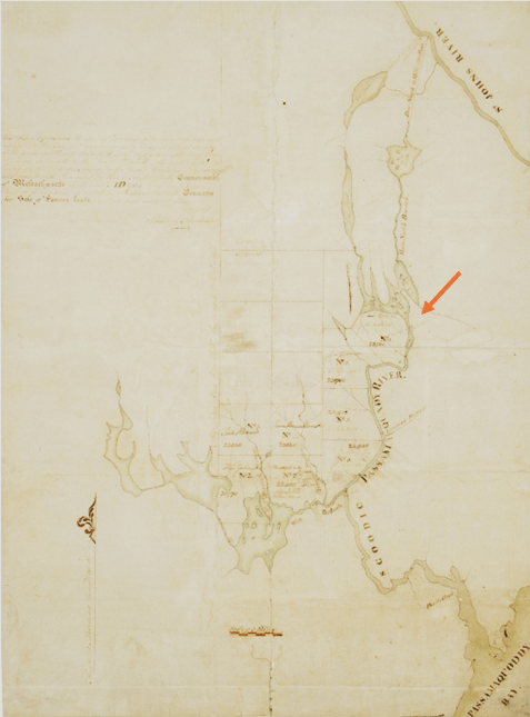
The Massachusetts Committee for Sale of Eastern Lands was responsible for the management of land in Maine to benefit the Commonwealth, especially land containing the largest white pines for ship masts. The Committee commissioned surveys of the main branch of the Schoodic (now known as the St. Croix River) from its northerly source at the St. John River to the mouth of Passamaquoddy Bay. The St. Croix is a one-million-acre watershed lying within the heart of the Passamaquoddy homeland.
According to the terms of the 1794 treaty between the Passamaquoddy Tribe and the Commonwealth of Massachusetts, the tribe was granted “… the privilege of fishing on both branches of the river Schoodic without hindrance or molestation and the privilege of passing the said river over the different carrying places thereon; all which islands, townships, tracts or parcels of land and privileges being marked with a cross, thus X, on the plan taken by Mr. Samuel Titcomb, with the reservation of all pine trees fit for masts on said tract of land to government; they making said Indians a reasonable compensation therefor…”
This map by Samuel Titcomb is the one referenced in the Treaty. Visible on the map are the notations mentioned in the 1794 Treaty, namely the “Indian carrying places” marked by dashed or straight lines across the river, the “Indian towns” marked by triangles, and the cross near Nemcass Point on the west branch of the river. Scale: 1 inch = 3 miles
SURVEYS & SURVEYORS
The first European mapmakers were the explorers who followed Columbus across the Atlantic. They made maps of the coast to show claims and grants. This mapping of the coast was continued by Samuel de Champlain starting in 1604, followed by Cypian Southack in 1631 and by the master mapmakers Samuel Holland and DesBurres from 1760 to 1775. Joseph Chadwick in 1764 mapped the first East – West highway, actually a water route. He started at the Penobscot at Passadumkeag, went up the river of that name, portaged to Upper Sysladobsis on St. Croix waters.
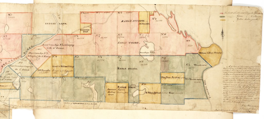
SAMUEL TITCOMB’S RETURN OF 1794 SURVEY OF THE MAIN NORTH BRANCH OF THE SCHOODIK (SD) WITH EIGHT TOWNSHIPS ON THAT RIVER AND LAKES
Original at Massachusetts Archives – Copy by John Pratt
This first describes Titcomb’s observations along the north and easterly shore of Palfrey Lake, up Palfrey Stream to Skiff Lake (or possibly Grassy Lake) hence due north eleven plus miles to the St. John River near Meductic Point. Titcomb surveyed eight townships in 1794 marked as TS. These bordered the St. Croix River and were north of Princeton.
T1 R3 TS (Lambert Lake) – (23,700 acres) T1 R4 TS (Vanceborough) – (23,700 acres). Note bounds with Lambert Lake and Kilgore (AKA Hill Gore) are at 45-degree angle to most township bounds. Titcomb tells the Committee for the Sale of Eastern Lands that he has marked the mill sites on the Plan. Also he rated the quality of the land as A, B, and C, and within each township is reported the “growth” being the species of trees observed.
CLOSER IN VIEWS OF TITCOMB’S 1794 SURVEY:


Moses Greenleaf’s information on the Titcomb Survey townships.
T1 R4 TS now Vanceboro granted to Williams College by Massachusetts in 1820
T1 R3 TS Lambert Lake NFI
T1 R2 TS (Daniel Jr.) Dyer NFI – to Maine in 1822 as a result of Statehood
T2 R2 TS (Benjamin) Waite of Calais
T3 R2 TS (Benjamin) Talmadge of Litchfield CT from Bingham Heirs
T1 R1 Ts now (Samuel) Fowler, was (Justin) Ely – to Maine in 1822
T2 R1 TS Indian Township – to Maine in 1822
T3 R1 TS now Grand Lake Stream was (Judge Samuel) Hinckley TWP
WASHINGTON, SS, SCOODIC RIVER JUNE 2D, 1794
Personally appeared Abial Sprague, Jun’r, Joseph Frost, Trueworthy Tuttle, and Joseph Pomeroy, and made oath to act impartially according to their best skill & Judgement in the capacity of chain men and assistants for Samuel Titcomb, agreeably to the instructions of the Committee for the sale of Eastern Lands dated April 3, 1794.”
1822
SILAS HOLMAN & COLONEL LEWIS SURVEY OF NORTHERN WASHINGTON COUNTY
In Roger Milliken’s book on the Baskahegan Company is a map of an area between the Penobscot and St. Croix. The survey was completed in 1822 and shows the land divided into townships “ready for settlers”. Shown are Range 2, townships 4 – 9, in Range 3, townships 6 – 11, and in Range 4 townships 6 – 9 plus Danforth Tract. Not all those townships are in Washington County. Topsfield and Kossuth may also have been surveyed by Holman and Lewis.
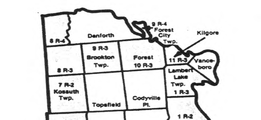
SURVEY – – 12-25-1822: Schoodic River; St. Croix River; Penobscot River; Titcomb’s Survey; Piscataquis River; Williams College Township; Hingham Academy Grant; Watt Township; Bascahegan Lake.

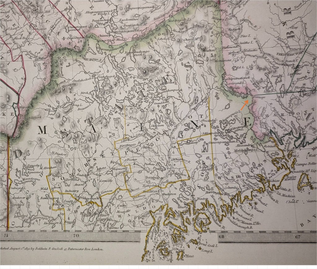
MAINE – 1832
Note then-defined Northern border. Present border established in 1842 after the “Aroostook War”.
The Aroostook War (sometimes called the Pork and Beans War), or the Madawaska War, was a military and civilian-involved confrontation in 1838–1839 between the United States and the United Kingdom over the international boundary between the British colony of New Brunswick and the U.S. state of Maine. The term “war” was rhetorical; local militia units were called out but never engaged in actual combat. The event is best described as an international incident.
Negotiations between British diplomat Baron Ashburton and United States Secretary of State Daniel Webster settled the dispute. The Webster–Ashburton Treaty of 1842 established the final boundary between the countries, giving most of the disputed area to Maine while preserving an overland connection between Lower Canada and the Maritime colonies.
WILLIAM ANSON – 1836
Vanceboro, owned by William Vance of Baring (with the State holding the mortgage) had no roads, no homes marked, but had an Indian Settlement. See also “Kill Me Quick” Rips on the river. The triangle gives the elevation for that part of the river and the rectangle gives bottom conditions and depths. All this was important for river driving.

Township 11, Range 3 NBPP was once called Hill Gore and now Kilgore. South of Kilgore is Lambert Lake Township and to the west is T 10, R 3 called Forest. Note the Hay Road and path to the settlement east of the lake. That bay of water north of the St. Croix is Palfrey Lake. Samuel Titcomb followed the north shore and up Palfrey Brook to Skiff Lake, then due north to Meductic on the St John River in 1794.

TOWNSHIP NO. 1 RANGE 3 – LAMBERT LAKE

TITCOMB SURVEY AREA IN 1881
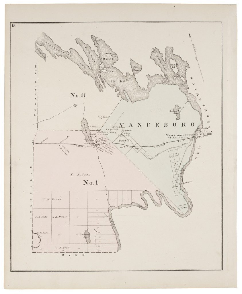
TOWN LAYOUT IN 1881
Note: New Brunswick & Canada RR line – crossing present vehicle bridge.

THE MASSACHUSETTS LAND LOTTERY
The Land Lottery was to pay off the war debt of Massachusetts. It failed. But the map/plan of Rufus Putnam showed a European style organization to the land. The war was over and a government was ready to give good deeds showing land ownership. In 1789, Washington County was created.
A SURVEY OF THE STATE OF MAINE by Moses Greenleaf – 1829
Grants to Academies & Colleges
From Greenleaf’s Survey of Maine
T1 R4 TS (Vanceboro) to Williams College 23,040 acres
T2 R3 TS (so half Codyville) to Hingham Academy 11,520 acres
T5 R1 N ( ) to Amherst Academy 11,520 acres
T6 R1 N ( ) to Lenox Academy 11,520 acres
Not Taxed
T1R4 Schoodic 23,040 Williams College (Vanceboro)
T3R2 Schoodic 23,040 B. Talmadge (Talmadge)
T3R1 Schoodic 30,770 S. Hinckley (GLS Plantation)
T1R1 Schoodic 24,050 Justin Ely (Fowler Twp)
T2R3 Schoodic 11,520 Hingham Academy (1/2 twp – Codyville)
T5R1 north of Lottery Lands 11,520 Amherst Academy
T6R1 north of Lottery Lands 11,520 Lenox Academy
At least three surveyors were involved in mapping out townships in this part of Washington County. Rufus Putnam in 1784 – 86 who surveyed for the Commonwealth of Massachusetts land some of what became William Bingham’s million acres. These townships carry identity as ED BPP or MD BPP. I believe another surveyor did the ND BPP and the Two Mile Strip. Samuel Titcomb surveyed eight townships in 1794 marked as TS. These bordered the St. Croix River and were north of Baileyville, Princeton, TWP 21 ED BPP and TWP 27 ED BPP.
RANGE 2
Township 1, Range 2 TS on the St. Croix River is called Dyer.
T3, R2 TS is the Town of (Benjamin) Talmadge.
T9, R2 NBPP (south half of today’s Codyville only) was once named Robbins [12 residents in 1840]. The Commission met at William Banks’ home on January 15, 1846, to set off three lots of 160 acres each.
RANGE 3
Township 1, Range 3 TS today is Lambert Lake Township. The Commission’s report did not mention anything about this township. [No 1840 census has been found]
T11, R3 NBPP is small and bounded on the east by the St. Croix River. The Commission met at the home of Daniel Lambert on December 2, 1845, and set off three 100-acre lots and called the place Hill Gore, now spelled Kilgore [30 people].
RANGE 4
Township 1, Range 4 TS is Vanceboro where the commission met at the home of Seth Walker on December 1, 1845. The map/plan of Vanceboro shows the St. Croix River on the east and the public lots in the western part of the township, but no roads. This township was named TWP 1 Range 4 TS on early maps. William Vance of Baring purchased that township on June 16, 1824, from the Agent for the Sale and Settlement of the State of Maine. The State held the mortgage for Vance, who immediately put his name on this piece of land. [no official population in 1840].
T1 R4 TS – VANCEBORO was incorporated as a Town in 1874
Population 1860 1870 1880 1890 1900 1910 1920 1930 1940
Vanceboro 573 707 1022 663 550 623 585 713 627
Population 1950 1960 1970 1980 1990 2000 2010 2020
Vanceboro 497 389 263 256 201 147 140 102
T1 R3 TS or T1 R2 NBPP – LAMBERT LAKE TWP
1868 detailed route of European & North American Railway approved by County Commissioners
1876 Petition for road from Vanceboro to Topsfield, denied, tried again in 1889 & 1890
1881 F. H. Todd + Charles F. Todd (Calais) / G. M. Porter of St. Stephen – farm lots on St. Croix
1890 organized – deorganized 1903
1907 Todd (Frank, Henry etc of St. Stephen NB) to St Croix Paper Co. 22920 acres
1963 St. Croix Paper Company to Georgia Pacific, 1978 mostly Georgia Pacific
2016 County Roads = two local roads
Population – 1850 = 23 / 1860 = 0 / 1870 = 246 / 1880 = 126 / 1890 = 152 / 1900 = 113 / 1910 = 104/ 1920 = 119 / 1930 =126 / 1940 = ? / 1950 = 158 / 1960 = 178 / 1970 = 100
T11 R3 NBPP KILGORE known in 1845 as HILL GORE
Population – 1837 = 20 in 5 families or households / 1840 = 30 / 1850 = 42 / 1880 = 13
1890 = 0 / 1910 = 8 / 1920 = 0
TANNERIES
The tanning process predated the arrival of Europeans here and was part of each settler’s community; shoes for the family and harnesses for oxen or horses were necessary. Generally large-scale tanning started in Maine about 1840 and reached its peak by 1880. In rural Washington County were tanneries at Beddington, Grand Lake Stream, Jackson Brook (Brookton), Princeton, Vanceboro, and Forest City. Large scale Tanning depended on three natural resources, water, hemlock bark and hides.
The hides were brought to Maine by ship from South America or the American Midwest. Out of work loggers and immigrants moved to the site and did the dirty work. Four tanneries were near rail lines. E. E. Church at Beddington and Shaw Brothers at GLS hauled a far distance by ox carts. This industry came to an end when hemlock bark was harder to get, and chemical agents became available and cheaper. The tanning giant Shaw Brothers made poor investments and failed in 1885. Their tanneries operated for another decade under a trustee. Shaw had at least two tanneries in Penobscot County, Lincoln and Kingman. Hemlock bark was getting scarce and was replaced by chromium and oak extract, chemicals.
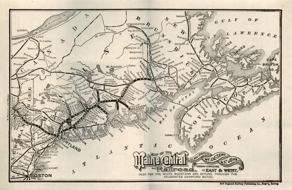
MAINE CENTRAL RAILROAD TRACKAGE 1890
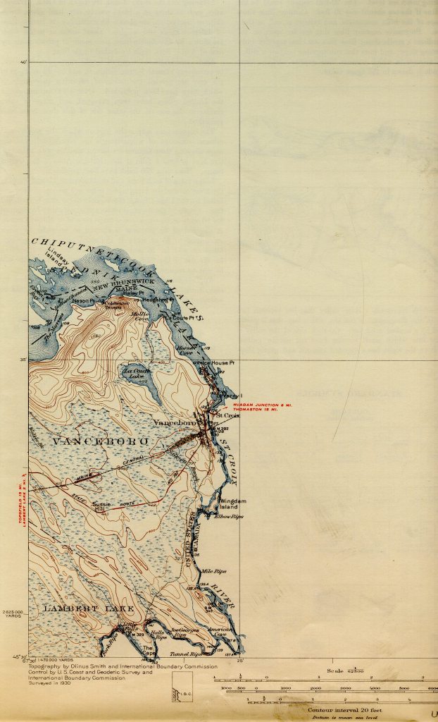
TOPO MAP 1930
1950 HIGHWAY STATE ROAD MAP

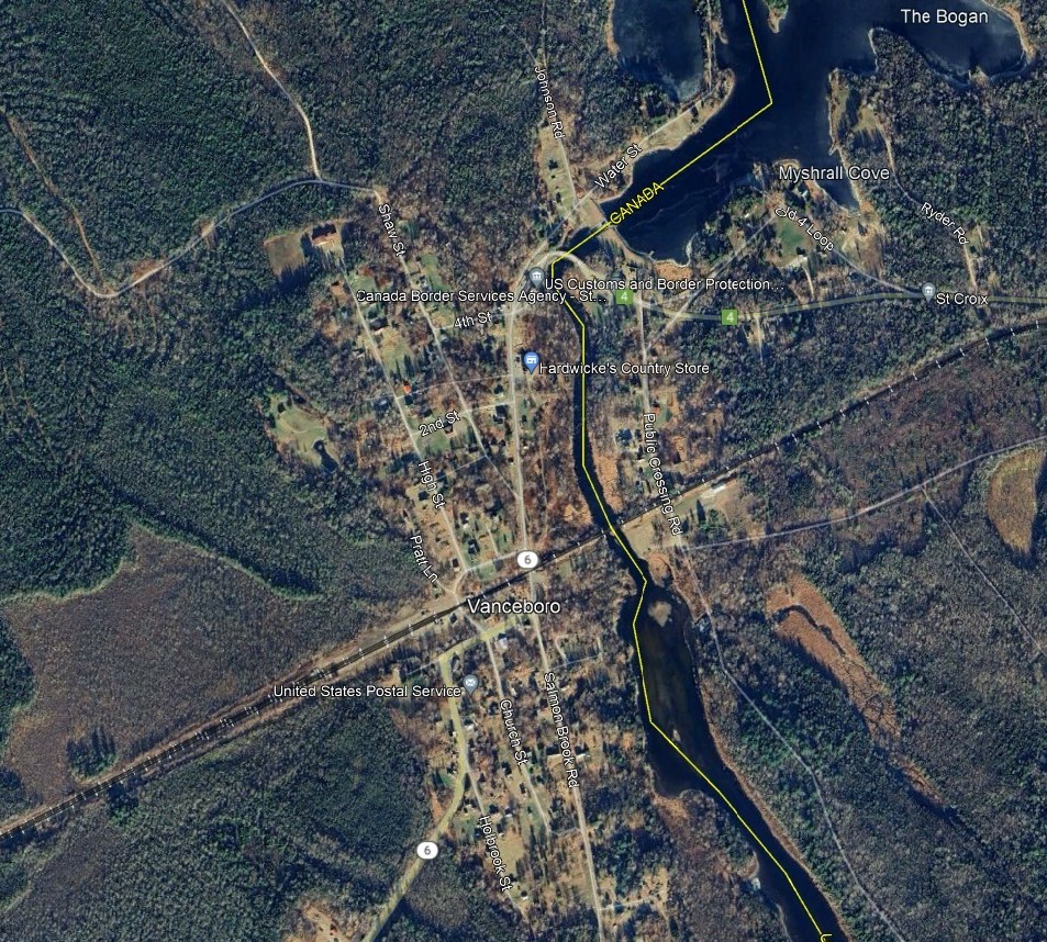
VANCEBORO 2024

_______________________________
- Author Note: Some of the narrative in this document is in the public domain, but most is excerpted from, and somewhat adapted, to address Vanceboro / Lambert Lake specifically. ↩︎
